


Har Ki Dun Trek And Many Stories | Uttarakhand Trek Guide (The Land of Pandavas, Duryodhan And A Missing Dhaki)
The Har Ki Dun trek allures you with the call to reach the Swargarohini Peak. The woods of Boslow and the low-key Devsu Thatch are other highlights of this trekking trail in Uttarakhand.
Further, the Har Ki Doon trek makes you pass through ancient villages, such as Gangaad, Datmir, and Osla. Once you are in these villages, you will feel like you are in a different time zone or world we don’t know about. The wooden houses, Kanda Rani, and other temples, and the deities inside and their cultural or religious events, tell the most intriguing tales about human lives.
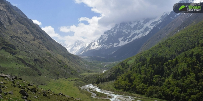
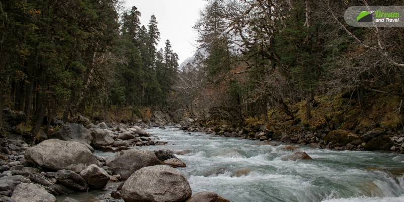
Moreover, the Thamsa River runs along the valley, and a little distant Swargarohini Peak exists as the eternal truth. Also, at Har Ki Dun, the microcosm of the universe unfolds before you. You get to see the most beautiful coexistence of nature, humans, trees, and animals.
So, are you ready to conquer this old and rich trek in Uttarakhand? Here, I share the things I know about Har Ki Dun.
| The amphitheatre-shaped valley of Har Ki Dun roughly translates to “The Valley of God.” This trekking tale is associated with the Mahabharata. Myths have it that the exiled Pandavas took the Har Ki Doon trail to reach the Swargarohini Peak. Further, from the Swargarohini Peak, they made a journey to heaven. Also, the ancient village of Osla on the route has a temple where Duryodhan, the cousin and antagonist of the Pandavas, is worshipped. |
Where Is Har Ki Dun Trek?
Har Ki Dun trek is in the Garhwal Himalayan region of the Indian state of Uttarakhand. Specifically, the trail is in the Govind Wildlife Sanctuary in Uttarakhand’s Uttarkashi district.
Govind Pashu Vihar Wildlife Sanctuary, or Govind Wildlife Sanctuary, has around 150 species of birds and 15 species of mammals.
Monal Pheasant, Western Tragopan, and Bulbul are some endangered bird species found here. Further, the mammals living here are Snow leopards, black bears, Himalayan black bears, Himalayan Tahr, musk deer, common leopards, and Serow.
| The Government of India runs the “ Snow Leopard Project.” at the Govind Wildlife Sanctuary. This project aims to conserve snow leopards of the region “through participatory policies and actions.” |
One Trek Route – Many Stories
The stories about the Har Ki Doon trek cease to surprise curious minds. The name has two meanings, the most popular being the “Valley of God.” The word “Har” refers to Lord Mahadeva, a part of the Holy Trinity of Gods in Hinduism.
Further, many call the land the “Sound of God” or the “Sound of Lord Shiva” as the devotees of Lord Shiva chant “Har Har Mahadeva.”
Every year, the local people celebrate a monsoon festival to worship Lord Someshwara or Lord Shiva. Many drummers gather at this festival, and the sound of their drums fills the air.
Local stories have it that a Dhaki (drummer) was lost many years ago on the day of this festival. Many people can still hear the distant sound of drums in the early morning during the Someshwara festivals.
Listening to stories from the elderly village people here about local myths, beliefs, and cultures is an experience!
How Difficult Is Har Ki Dun Trek?
The Har Ki Dun trek difficulty level is easy to moderate. However, you will be climbing up to an elevation of 3500 meters. Also, your journey will start from Kotgaon, which has an average elevation of 1,540 meters from the sea level. Further, you will need to trek for around 10 Km every day.
When I asked my father how difficult it would get, he took a few moments to ponder it. Then, he said,
| “See, apart from the Boslo to Chillurgad trek, you have to trek for close to 8-10 Kms every day for 5-6 days. So, you need to have good lung capacity, and your legs should be really strong.” |
Moreover, there are no provisions for multiple exits during the Har Ki Dun trek. The path to the valley is the only exit point of the trek. You must prepare for the Har Ki Dun trek at least one month before you set in. Physically and mentally, train yourself to cover 5Kms of route within around 35 minutes. Your fitness resume must include the following activities.
• Jogging
• Running
• Walking
• Core Exercise
• Leg Muscle Workouts, such as lunges and squats
• Ascending and descending trail
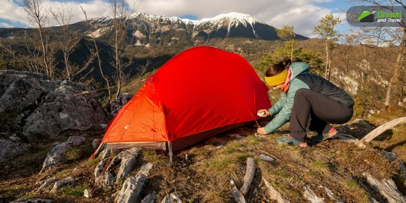
You can join an adventure training organization to learn the skills of ascending and descending on the trails and other mountaineering skills. The mountaineering skills include using gaiters and microspikes correctly and how to set up a tent.
The death of a 34-year-old trekker from Kolkata during the Har Ki Dun trek in 2022 shook us all.
| Dipanjana Banerjee, an I-T officer from Kolkata, lost her life to a cardiac arrest during the Har Ki Dun trek in 2022. She had conquered some more difficult terrains, and her last trek before this was to Dzukou Valley in Manipur. |
So, before you set in, you must have a complete assessment and understanding of the terrain, altitude, weather conditions, hospitals, and emergency exits.
Terrain Safety
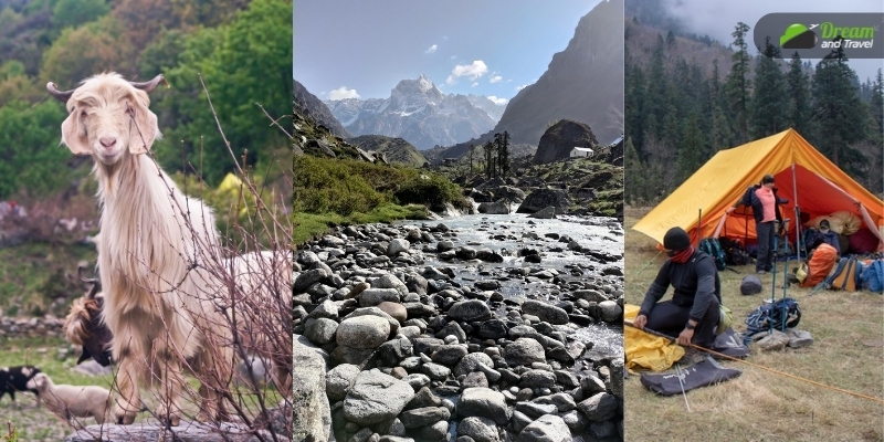
The Har Ki Dun trail continues along the Thamsa River. So, as you advance on the trail, you must cross streams or rivers almost constantly. Further, the bridges on those rivers (wooden or concrete) are often washed off due to the rampage of the river or extreme weather conditions.
In such cases, you must cross the streams with a “rope and pulley system.” You must have the right fitness level and training to sail through this activity.
Altitude And Acute Mountain Sickness
There is a quick rise in the height when trekking the Har Ki Doon trail. Especially near the Kalkathiyadhar campsite (2730 Meters), many trekkers fall prey to Acute Mountain Sickness (AMS).
Lack of sleep and appetite, nausea, and a long-lasting headache are common symptoms of AMS. Diuretic medication can help to cure these conditions. However, have prior permission from your physician, and you can even consult the doctors at the medical facilities at Mori, Purola, and Barkot.
However, if the symptoms refuse to go away even after taking diuretic medicines followed by a 10-12-hour rest, you must consider returning to Kotgaon, where your journey started.
Weather Conditions And Injuries
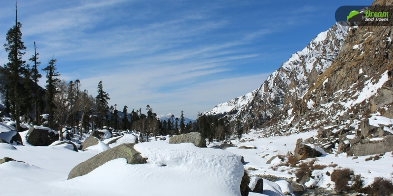
If you are trekking Har Ki Doon in the summer (May-June), you will see snow from the Kalkatiyadhar campsite. Further, in winter (December-April), the snow will be there as you enter the trail.
So, for most of the year, the Har Ki Dun Valley has snow, and as the sunlight fails to enter the deep valley, the snow does not melt easily.
However, the hard snow terrain gets slippery, and if you don’t observe caution or wear your microspikes, there are high chances of accidental falls and injuries.
Hospitals And Emergency Exit
Har Ki Doon trek has only one exit route. To abandon the trek, you must come to Kotgaon or Taluka. Further, there are hospitals in Mori, Purola, and Barkot. In these hospitals, you can get treatment for minor health issues, including sprains, ligament tears, and injuries.
However, if you are facing major health issues, you have to come as far as Mussoorie or Dehradun. Both these places are around an 8-hour drive from Kotgaon, the base camp of the trek route.
What Is The Har Ki Dun Trek Distance? (With Complete Itinerary)
The Har Ki Dun trek distance is around 45 Km. This is a round trek to and from Kotgaon. In the itinerary here, we are starting our journey from Dehradun and reaching Kotgaon after a drive of approximately 200 Kms.
If you are concerned about “how to reach Har Ki Dun trek base camp” from Dehradun, you can ask the hotel where you are staying to organize a ride to Kotgaon. Based on your budget, you can take a shared cab or a temp traveler.
Nevertheless, let the seven-day-long journey begin!
| Day | Route | Distance Covered | Time of Traveling | Change of Altitude |
| One | Dehradun to Kotgaon | 197 Km | 10 Hours (Approximately) | 450 to 1,540 Meters |
| Two | From Kotgaon to Dhatmeer by Drive & Trekking to Gangaad from Dhatmeer | 14 Km by Drive and 6 Km Trek | 2 Hours Drive and 5 Hours of Trekking | From 1,540 Meters to around 2500 Meters From 2500 Meters to 2337 Meters |
| Three | To Kalkatiyadhar from Gangaad (Via Osla) | 7-8 Km | 6 Hours | To 2730 Meters from 2337 Meters |
| Four | Reach Boslo from Kalkatiyadhar (Via Har Ki Dun Valley) | 9-10 Km | 6 Hours | From 2730 Meters to 3280 Meters |
| Five | To Chillurgad from Boslo | 6 Km | 5.5 Hours | From 3280 Meters to 3000 Meters |
| Six | Trekking to Dhatmeer from Chillurgad and drive to Kotgoan | 14 Km trek distance and 14 Km drive distance | 7 Hours Trek and 2 Hours Drive | From 3000 Meters to 2500 Meters and then to 1540 Meters |
| Seven | Back to Dehradun from Kotgoan | 197 Km | 10 Hours (Approximately) | 1,540 to 450 Meters |
You will have to carry a photocopy of your medical certificate and ID and show them at the forest check posts. Further, the road to Kotgaon (from Taluka) can get blocked in case of extreme weather conditions. So, you may need some extra hours and extra days to complete your trek.
The Har Ki Dun trek package can be around INR 12000-14000 per person, including food, accommodation, and transportation. However, carry some extra money for medical emergencies and your personal expenses.
Exploring The Har Ki Dun Trek: The Best Trekking In India
The Har Ki Dun Trek has many highlights as you start your journey to the Swargarohini Peak. The journey is as beautiful as the destination. Let’s explore the best places to see.
Swargarohini Peak
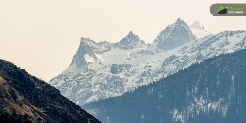
At an altitude of more than 6200 Meters, Swargarohini Peak attracts many trekkers every year. The peak visible from the Har Ki Doon Valley itself has a distinct trekking route starting from the village of Sankri.
Swargarohini Peak presents the beauty of the Garhwal Himalayas at its best. Further, with a high altitude and changing terrains, it is a challenging trek that ensures a transformative experience.
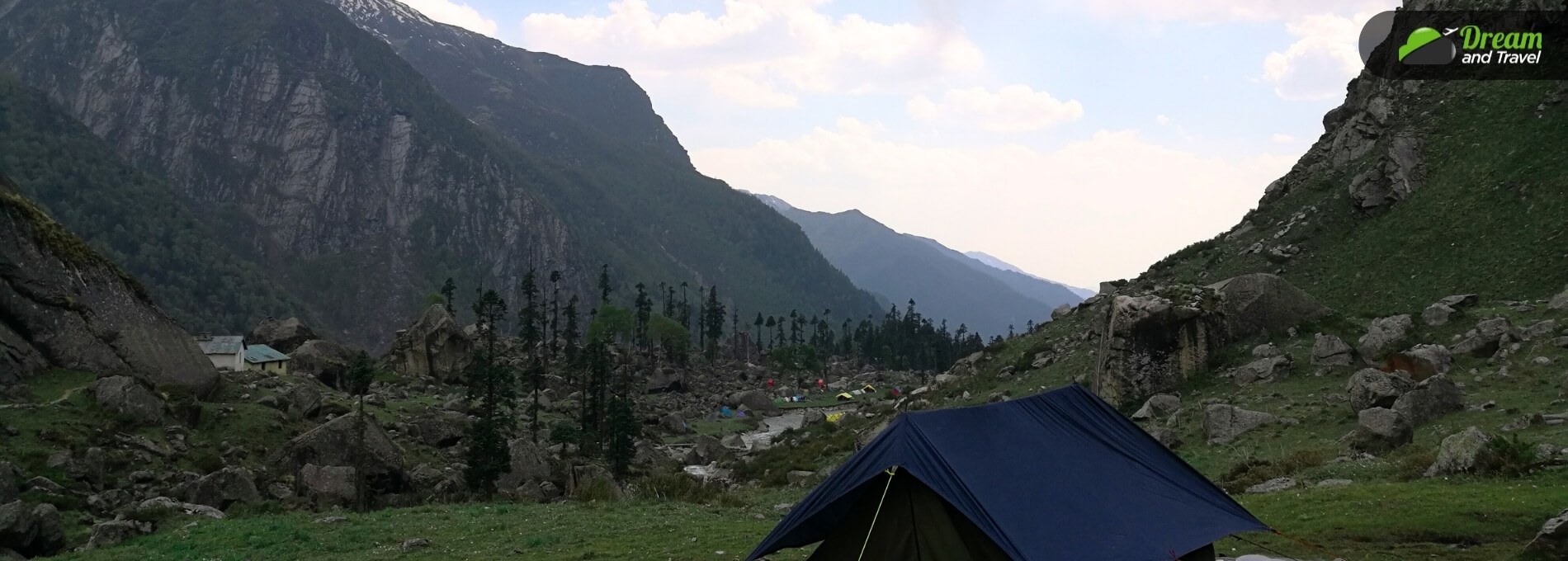
Har Ki Doon Valley
The Har Ki Doon Valley has many streams and snow-clad mountains that embrace it, making the visuals ethereal. It has a unique amphitheater shape, and Bugyals, or Alpine pasture lands, surround it.
Village Of Osla
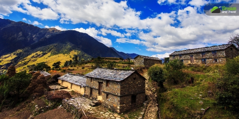
Osla, one of the ancient villages of Har Ki Doon, has many homestays. Living in these homestays will give an entry into the fascinating lives of the local people. The Garhwali food here has the essence of the soil and the smoky flavor of the wood-fired ovens where the dishes are cooked.
Don’t forget to try delicacies like Manduva roti, red rice, daal, and Kafli. Osla also has a temple which is 5000 years old. It is the Duryodhan Temple, as I have mentioned earlier. However, today, people call it the Someshwar Temple, where Lord Shiva is worshipped.
The craftsmanship of this temple is mesmerizing, and you can see similar work in the old wooden houses of Har Ki Dun.
Jaundhar Glacier
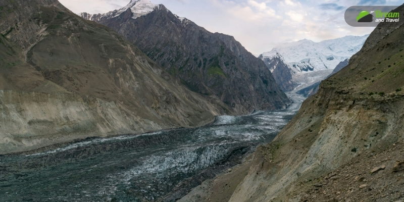
At the Swargarohini peak base, you will find the Jaundhar Glacier. You can trek from Har Ki Dun Valley to the Jaundhar Glacier View Point for around 5 Kms.
The viewpoint is 2-3 km from the Jaundhar Glacier.
Hata Valley
With Alipine meadows, Hata Valley offers the best view of the Hata Peak. The peak is 5,820 Meters in height. Also, Hata Peak is the division point between Himachal Pradesh and Uttarakhand.
Devsu Thatch
Above the Supin River stands Devsu Thatch, a hidden gem in the Har Ki Dun trek route. At an elevation of 3058 Meters, Devsu Thatch enjoys the embrace of forests, creating a multi-tiered effect. You can also see flowers such as marigolds, daisies, primulus, poppies, anemones and orchids here.
You can enjoy a natural walk on the soft grass of this meadow.
Know The Best Time For Har Ki Dun Trek Before You Set In…
Har ki Dun trek is famous as it remains accessible for almost 7 months a year. However, September to December and March to June are the best months to trek this path.
Spring in the valley sets in March, and summer continues until June. Further, it’s monsoon season in July, and due to the heavy rainpour, the Govind Pashu Vihar Sanctuary shuts its doors (July-August).
Trekking resumes on this route in September, and the trail looks fascinating with the snowfall from October to December. However, from January to March, the Har Ki Dun trail remains closed under the directive of “The Forest Department of Uttarakhand.”
Similar posts..