Well, Kashmir can get quite crowded during the tourist season, and that is not something you already don’t know. If you have planned a trip to Kashmir, you have planned it while keeping all the things in mind, I believe.
However, even if you are visiting Kashmir during the tourist season and still want to get away from the maddening crowd, there are some less visited places in Kashmir that are going to capture your heart and mind, and one such place is Doodhpathri.
Even though the Jammu and Kashmir tourist board is promoting and developing the place, it is not yet popular among tourists. If you are looking for a moment away from all the chaos, then this is a place you should definitely visit. This is also one of the best places to visit when you are in Srinagar.
Looking Back
If you are looking for the literal meaning of the place, it is the “valley of milk.” History has it that Kashmir had a famous saint named Sheikh ul Aalam, Sheikh Noor din Noorani who prayed here. He was looking for water in the meadows for praying, and the moment he pricked the ground in search of water, it was milk that came out.
It is said that the milk changes its form to water immediately after he told milk can only be used for drinking and not for cleaning or any other purpose. That is how the place got the name “Doodhpathri.”
However, the water that flows has a milk-like appearance when seen from a distance, and it remains cold all through the year. The silver streams flowing through the meadows and the lush green valley enhance the beauty of the place.
This place has grassy landscapes and a diverse range of multicolored flowers that go up to Chang. The infamous Tosamaidan is also placed in the western part of Doodhpathri.
Geography and Demographics
Doodhpathri is located at the height of 2,730 m above sea level and is right in the center of a bowl-shaped valley in the Pir Panjal Range of the Himalayas. The sow-covered Alpine valley looks beautiful, covered with the meadow of Deodar and Pine Fir.
These snow-covered meadows, in the winter, grow the most beautiful wildflowers like butter cups, forget-me-not, and daisies during the summer and the spring. Because of the heavy snowfall, doodhpathri is not accessible during the winter.
How to Reach Doodhpathri?

You can reach Doodhpathri by air, by train, or by road. If you are traveling by air, then Sheikh-ul-Alam is the nearest airport. Doodhpathri is around 40 km from the airport, and it takes about an hour to get there.
The nearest railway station is Ompora tow in Budgam district, which is around 35 km from Doodhpathri. And if you are traveling by road, you can access the place by just a 1.5 hr drive from Srinagar.
To reach there, you have to travel from Srinagar to Budgam, and from there, you have to travel to Khansahib, and from Khansahib, you have to travel to Doodhpathri vis Raiyar. The entire route is around 45 km.
You can also take the Srinagar Gulmarg road. Here, you have to cover a total of 50 km and travel from Srinagar to Magan; from Magan, you have to go to Beerwah and, from there, to Arizal.
Doodhpahtri trek

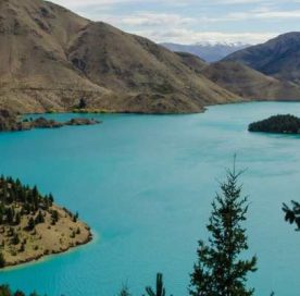
Doodhpathri trek takes you deeper into the valley to the alpine lakes of Damamsar and Bhansar. These hidden lakes are going to peep out and surprise you during the treks. If this is your first trip to Kashmir, you should know that every trek that you take in Kashmir justifies the title it has, “heaven on Earth,” and this is no different.
Short itinerary
- Day 1: Travel from Srinagar to Doodhpathri
- Day 2: Doodhpathri(8,945 ft) – Marak (10,540 ft). This covers a distance of 5km and takes around 3 hrs.
- Day 3: Marak (10,540 ft) – Kooterlass (11,850 ft). This covers a distance of around 505 km and takes about 3.5 hrs to reach.
- Day 4: Go for an excursion to Damamsar (13,226 ft) and get back to Kooterlass. It is 6 km away and would take you 4 hrs to cover the road.
- Day 5: Kopterlass (11,850 ft) – Ashtaar (11,576 ft). It covers a distance of around 5 km and takes around 2.5 hrs to get here.
- Day 6: Ashtaar (11,576 ft) – Mujakhani (9,754 ft). It covers a distance of 9 km and takes around 4.5 hrs to reach.
- Day 7: Mujakhani (9,754 ft) – Palmaidan and more into Srinagar (7, 345 ft). This is almost 8 km from Mujakhani and would take you around 4 hrs to get there.
Day 1: Srinagar-Doodhpathri

Doodhpathri camp is 22 km from Budgan and 42 km from Srinagar. You can get to Doodhpathri by cab from the airport or the city. It takes around 2 hours to get to your destination, and a private cab can cost you approximately Rs. 1,800 – Rs. 2,000. However, you can also take a bus from Khan Sahib or Budgam.
Day 2: Doodhpathri – Marak
From Doodhpathri, you start to follow the picturesque pine and deodar forest, and after half a mile, you hear the sound of the Shaliganga river on the right side of the valley. From there, you have to follow a muddy trail to get forward.
When you go up through the muddy trail, you will see the Budgam district from the horizon. After walking almost an hour from there, you get to a stream and to reach the campsite, you have to walk another half kilometers.
At the top, there are two huts, and the panoramic view of the entire valley and the mountains from there is something that is going to stay engraved in your mind forever.
Day 3: Marak – Kooterlass
You have to take the route behind the camp to get to the top of the ridge and get a glimpse of the route for your next expedition. You get a wide-angle view of the Shaliganga River, and walking down the trail is your route toward Kooterlass.
Walk down almost 700 meters and take the trail, which is just next to the river. You have to climb for nearly an hour and reach the opening between the two hills. If you follow the trail by the river for the next two hours, you will get to your campsite.
The campsite is in a beautiful meadow, and there are various small streams that surround the meadows, which are also the water source of the campsite.
Day 4: Excursion to Damamsar, Then Get Back to Kooterlass
For this one, travel lightly, because you are going to come back to the campsite. Take the ascending trail and walk for almost one and a half hours, and you will find the Bhansar Lake in front of you.
This is a glacial lake surrounded by boulders. However, there is no definite trail that you can follow to the next lake, as the place is covered with huge boulders. Be cautious and climb gradually, and eventually, you will have the beautiful Damamsar Lake before you.
Compared to the previous lake, Damamsar Lake is double in size. The view of the crystal clear waters is going to soothe your eyes. After spending some time, take the trail left to the boulders and get back to the campsite.
Day 5: Kooterlass – Ashtaar
You start with a gradual ascent on the right side of the trail, and the route is just below the one you took the previous day. Then you have to climb for almost 2 hrs and reach the end of a flat ridge. You can also spot the peak Tatakuti close to the Ashtaar glacier.
During the month of July, the entire valley is filled with red and yellow flowers. The meadows here are wider than the ones you saw in Kooterlass. Descend down into the valley. After walking for around 2.3 kilometers, you get to the Ashtaar campsite.
Day 6: Ashtaar – Mujakhai
The trek starts with you crossing the Shaliganga River, which is just beside the campsite. It is not difficult to cross the river, as the water is only knee-deep. After crossing the river, you have to ascend the hill gradually. After walking for half an hour, you will come across the vast meadow with a few shepherd’s hut.
You get a view of the Ashtaar Glacier on your right side, and as you move forward, you get an amazing view of the Doodhganga, which also originates from the glacier. Take the trail on your right toward the meadow, and you will get a glimpse of your next campsite.
As you descend along the Doodhganga River for almost 2 kilometers, you get back to the tree line. Walking another 2.5 kilometers would take you to your campsite.
Day 7: Mujakhani – Palmaidan
This is the last day of the trek and is not very difficult. You mostly have to walk through the same trail and in the same direction that you walked the previous day. Moreover, as you walk down for almost a kilometer through the forest and follow the stream, you will hit the stone trail. Walk on this trail for the next 2 hrs.
In the next 30 minutes, you will walk into an open meadow with a few shepherd’s huts, which marks the beginning of Palmaidan. Walk ten more minutes on this trail, and you will get an amazing view of this civilization on your right side.
Wrapping up!
The meadows of Doodhpathri, with the Shaliganga river cutting through the valley, are gems of Kashmir. Away from the commercialized tourists, this is one of the best spots to visit when you are in Kashmir.
You will have an amazing experience going through this trek, and of course, the view of the Ashtaar glacier and the lush green meadows is going to soothe your eyes.


